


| A379 at Slapton Sands in south Devon - sea related incidents Posted by REVUpminster at 17:11, 16th February 2021 |     |
The east-facing section of Devon coast from the Exe estuary south to Start Point has always faced a battle with the elements, which it invariably loses. Anyone wanting to understand this should read the history of Hallsands, where the original village was completely wiped out by a succession of storms during the first years of the 20th century, with waves sometimes breaking right over its houses. Eventually the last buildings were lost in 1917, and a new village built inland. That village is now on the coast, and will face the same battles.
Agree with this. Slapton Sands A379 is again under threat and may not be rebuilt if it goes again.
Hollicombe Beach between Torquay and Paignton is another risk that if it went would be very difficult to repair. Nearby cliffs by Institute beach are being hollowed out by the sea and I wonder how secure Cliff Court apartments are.
| Re: A379 at Slapton Sands in south Devon - sea related incidents Posted by Mark A at 16:32, 3rd February 2026 | |
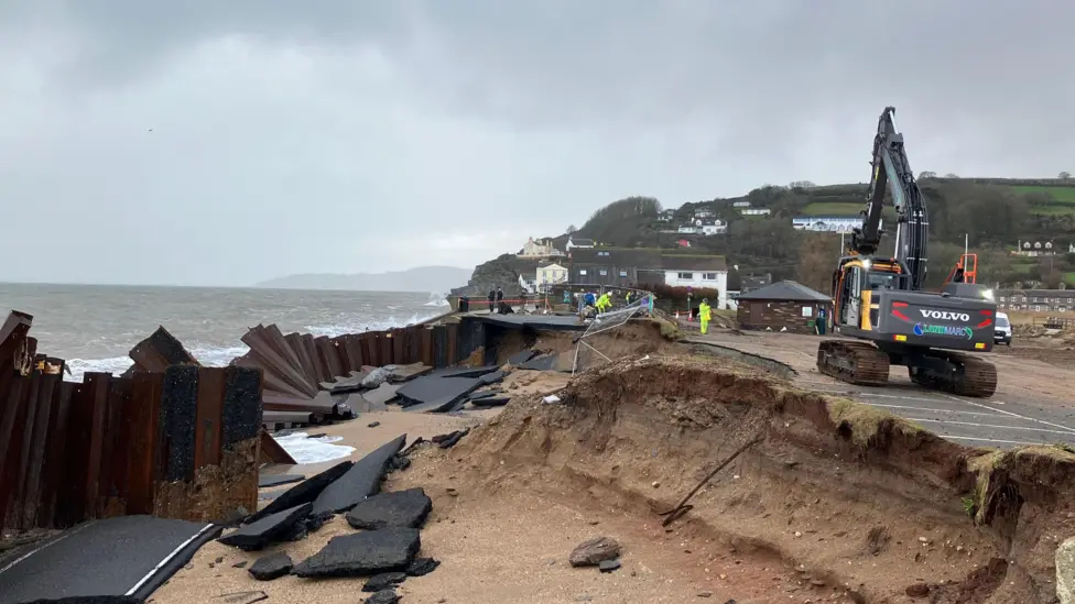
The road at Slapton is on a shingle beach backed by a freshwater lake. Or rather, that's what it *was* on, the sea has removed a substantial length of the road. The A379 carries the bus route from Dartmouth to Kingsbridge.
Mark
https://www.itv.com/news/westcountry/2026-02-03/its-like-a-bombs-gone-off-shock-as-part-of-a-coast-road-is-washed-away
| Re: A379 at Slapton Sands in south Devon - sea related incidents Posted by Bob_Blakey at 09:27, 4th February 2026 | |
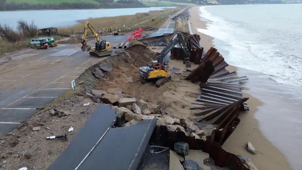
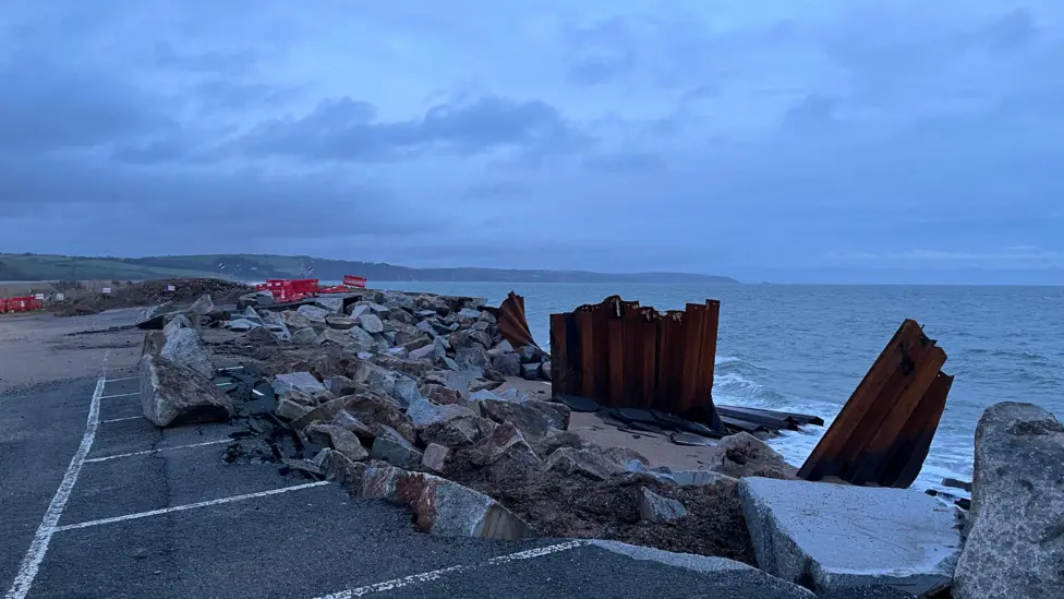
The presence of (severely deformed) sheet piling indicates that this is almost certainly the same A379 section that was destroyed by Storm Emma in 2018.
In which case Devon County Council and/or National Highways should probably be looking for a much more robust solution this time.
| Re: A379 at Slapton Sands in south Devon - sea related incidents Posted by Marlburian at 12:06, 4th February 2026 | |
I took part a couple of times in a cycle race that started and finished in Totnes and went along the road. I also did some recreational cycling in the very hilly lanes (on one occasion a brake cable had snapped, which made descending a bit dodgy).
On the news last night there was a reference to the tank park where, presumably, Ken Small's tank is still parked.
I still have a large sea shell from the beach.
| Re: A379 at Slapton Sands in south Devon - sea related incidents Posted by Mark A at 13:23, 4th February 2026 | |
I read that as "I still have a large shell from the beach", and went pale.
Mark
| Re: A379 at Slapton Sands in south Devon - sea related incidents Posted by grahame at 14:49, 4th February 2026 | |
The presence of (severely deformed) sheet piling indicates that this is almost certainly the same A379 section that was destroyed by Storm Emma in 2018.
In which case Devon County Council and/or National Highways should probably be looking for a much more robust solution this time.
In which case Devon County Council and/or National Highways should probably be looking for a much more robust solution this time.
Perhaps they should look for a northern route going the other side of Dartmoor .... oh ... wait ....
| Re: A379 at Slapton Sands in south Devon - sea related incidents Posted by bradshaw at 17:41, 4th February 2026 | |
When I first visited the beach in the 1960s it still had the notices warning of unexploded ordnance.
| Re: A379 at Slapton Sands in south Devon - sea related incidents Posted by johnneyw at 18:42, 4th February 2026 | |
When I first visited the beach in the 1960s it still had the notices warning of unexploded ordnance.
Back in October 1977 I spent a few days at the Slapton Field Studies Center as part of my A Level Geography course. The whole group were walking back along the coast path from Start Point but myself and a few others were among the stragglers. The ones ahead of us actually saw (and heard) a wartime mine, discoverd that day on Slapton Sands, being detonated by the bomb disposal chaps.
We didn't see or hear a thing, which rather puts a perspective on my definition of "stragglers".
| Re: A379 at Slapton Sands in south Devon - sea related incidents Posted by TonyK at 22:15, 5th February 2026 | |
I have very fond memories of times around there when my kids (now in their 40s) were little, including walking up to the foot of Start Point lighthouse at the very moment the foghorn was tested, and dinner at the pub. It is going to cost a lot more to fix than the local council has. As yet, no word on how it will be achieved, but Slapton Ley ticks every conservation box there is. If that is breached, then - well, I don't know what will happen for sure, but it would be extremely sad.
| Re: A379 at Slapton Sands in south Devon - sea related incidents Posted by Chris from Nailsea at 21:15, 7th February 2026 | |
From the BBC:
South Devon MP starts petition after A379 Slapton coastal road collapse
Part of the A379 Slapton Line near Torcross, Devon, collapsed during stormy weather on Monday night
Thousands have signed a petition calling for more government support for those affected by storm damage to a coastal road.
Caroline Voaden, Liberal Democrat MP for South Devon, set up the petition following the partial collapse of the A379 Slapton Line near Torcross, which has caused disruption in the area. As of 09:30 GMT on Saturday, more than 9,500 people had signed the petition, which calls for help for "communities affected by coastal erosion in Start Bay".
The government said it was aware the storm damage was a "big shock" to residents and that it was working with the county council to determine its "next steps". A government spokesperson said: "We are providing over £443m for roads maintenance in the area over the next four years, along with £667m across the UK into protecting communities from the sea."
The road is set to remain shut for an extended period after an estimated tens of millions of pounds of damage was caused.
County council leader Julian Brazil apologised after he suggested the road might not be repaired, which sparked angry comments from residents.
Voaden said the response to the petition showed the "strength of feeling about the crisis" and how worried people in the community were. "Communities affected by coastal erosion at Start Bay are the canary in the coalmine in our fight against climate change," she added. "The government must treat this issue with the seriousness and urgency it deserves."
(BBC news article continues)
| Re: A379 at Slapton Sands in south Devon - sea related incidents Posted by Chris from Nailsea at 21:21, 7th February 2026 | |
In many years gone by, I have driven along that stretch of road (when it was still there, obviously.
 )
)| Re: A379 at Slapton Sands in south Devon - sea related incidents Posted by Chris from Nailsea at 23:17, 12th February 2026 | |
An update, from the BBC:
'No promises' washed away Devon coastal road will be reopened
Caroline Voaden MP spoke with the water and flooding minister and roads minister on Wednesday
There are "no promises" a scenic coastal road in Devon that washed away during stormy weather will be repaired, the local MP has said following talks with ministers.
Parts of the A379 between Torcross and Slapton were damaged when its sea defences failed during recent storms.
South Devon MP Caroline Voaden spoke at Prime Minister's Questions and then met ministers over how £10.5bn of funds to improve coastal and flood defences could be accessed. She also said the Department for Transport was open to a submission by Devon County Council for the "repair and reopening" of the A379 "and/or" improvements to "the back roads", adding: "No promises were given but I will ask DCC to provide an estimate".
Voaden told BBC Radio Devon: "No decisions can be made until they had an idea of what that's going to look like financially." She said parts of her meeting on Wednesday with Minister for Water and Flooding Emma Hardy and Minister for Roads and Buses Simon Lightwood were "positive".
The road was damaged by storms more than a week ago
Voaden also raised the possibility of an "ambitious coastal defence scheme", which could see the replacement of shingle into the bay and an offshore barrier to give the area "more stability in the long term and protect the shoreline from more storm damage". She told the House of Commons on Wednesday about the "complexity of the situation".
In response, Prime Minister Keir Starmer said: "I know communities have been badly affected by recent storms and damage to the A379 is very concerning." He said the government was investing to improve coastal and flood defences. "I want to thank the Environment Agency (EA) staff for working hard right now putting extra protections in place and supporting people ahead of further wet weather," he said.
Resident and landlady of local business Start Bay Inn, Gale Stubbs, said she and her two children were born and raised in Torcross, so understood the importance of the A379. She said her biggest concern was the homes along the seafront, adding they had to be the "priority".
Stubbs said the community was grateful for the ongoing work but desperately needed more sea defences in front of the village "quite urgently".
Voaden added the Environment Agency (EA) owned the sea wall and teams had been working "really hard" to try and do what they could "to make sure the houses are safe". At the meeting, she said she had asked the Department for Environment, Food and Rural Affairs (Defra) to give the EA funding to do more repair work and restoration in front of the houses "more quickly" than if they went through normal channels.
"The EA has a long list of jobs that are on their list to do and, when something like this happens, there can't be something that goes to the top of the queue," she said. "I have been contacted by the head of the EA who is happy to meet with me." Voaden added: "It feels to me everybody is being as proactive as they can be."
A Defra spokesperson has previously said: "We're committed to supporting coastal communities, including in the South West, through our record investment of £10.5bn in protecting against flooding and coastal erosion by 2036, benefitting nearly 900,000 properties." It also has said that it inherited flood defences in the worst condition on record and had reprioritised more than £100m into urgent maintenance works across the UK.
| Re: A379 at Slapton Sands in south Devon - sea related incidents Posted by johnneyw at 22:39, 13th February 2026 | |
It's a very sorry sight indeed. I've been down the Slapton Line many times over the last half century, whether by foot, car, bus or coach.
The local MP Caroline Voaden made an appeal in parliament to the PM pointing out how the local community had twice served the nation to their cost last century. Firstly with the offshore dredging to help build the Plymouth breakwater for the Royal Navy which resulted in the eventual destruction of Hallsands (and arguably contributed to this year's damage at Torcross). Secondly with the wartime evacuation of the communities to facilitate D-Day training in The Second Word War.
The Slapton Line repair could, in this context, be seen as a much delayed and meaningful act of gratitude and recognition.
